GPS Hell

Every time I’ve used a GPS unit this term there have been problems. The nature of the problems vary, but generally, they stem from a number of issues:

  • No one charges them and people return them with about 5 minutes of battery life left so you have enough to load your data dictionary and start walking to do your survey when the unit dies.
  • If there’s a hardware problem, people just turn them back in and get a different one, so no one knows when a unit is having a problem
  • What did you expect when you put Windows in a GPS unit?
  • There are 7 units and 40+ people in the class
  • can we ever move away from COM ports?

Instead of being halfway done with my survey I’m scouring Trimble’s website for help with determining why COM3 is in use by some phantom program that isn’t in the task list and why the GPS won’t connect to the PocketPC. I wish I’d been given one of the Geo3 units. They at least work consistently.

Barley’s Mental Map

Every morning Barley runs down the front steps and takes a right. He’s gotten so predictable that I decided to let him lead the entire walk and see what kind of map formed. What made Barley’s mental map of the neighborhood? Was it the markings of other dogs? People?

Well, we never found out because we only made it to the end of the block before Barley had satisfied himself with the latest marking before looking to me to decide on directions. Not much of a map. The rest of the walk I tried to let him pick which way to go (except up people’s walkways) and it seemed his default was to go straight or look to me for some small cue about direction. I was a longer walk than normal and he never gave me the sad eyes when he realized we were turning back towards the house. Still, not quite what I was hoping for. No GIS project.

Yahoo Maps Beta

movement in yahoo maps
I stumbled upon Yahoo’s maps beta while reading fark today and wanted to see what made it unique. I love google maps, so Yahoo has some impressing to do if they want to woo map geeks.

My First impression is that the interface is kind of busy but not in a work stopping kind of way. The tool uses Flash which is kind of choppy on my 3.8GHz work machine. There’s a live zoom tool and panning which is one of the greatest features of goggle maps. It makes for improved discovery to be able to pan around and see the area around your point of interest and judge scale and location.

A big improvement is the multi-stop destinations. For a sample I did a map of my westward migration since birth (right) which yahoo attached some driving instructions for. This will be a lot of fun and quite useful because no matter how much you’d like to stop by some place on your trip from A to B, most web mapping services don’t allow it.

There’s also a Live traffic tool which I remember hearing about last year at the WebVisions conference. There’s also support for yahoo’s local directory which like google’s is of only limited usefulness.

It’s still in beta, but it looks pretty good.

Portland Traffic

Yesterday’s Colloquium was presented by Robert Bertini of the Civil and Environmental Engineering Department. It focused on transportation and how it has shaped the development and land use in Portland. The gist of the talk was that transportation was key in locating Portland as a major city and that each new mode of transportation tends to follow routes created by previous modes.

The slide show that accompanied the talk had some great historical photographs and maps from the last century. One of the slides was a map of streetcar routes from the early 1900s which included an Alberta line. Most of these older routes were buried under the street network as cars became more popular.

There was brief discussion about the future of transportation especially as it relates to traffic jams in Portland and the looming sense that we can’t build ourselves out of the congestion we’re seeing today, which is why Portland has focused on other modes of transportation and other alternatives for coping with growth.

I was tempted to ask about the Segway because I remember people saying that it would change the way cities were built and such. While I do agree it’s a brilliant piece of technology (controlled falling … like walking) it just hasn’t caught on. In fact, it appears that bicycle ridership has instead boomed. And why not? The cost of a bicycle is much less and the I’ve only seen one “Segway” rider and it was a kid riding a knock-off that had four wheels getting passed by droves of cyclists in the bike lane on Vancouver Ave.

I’m really curious about transportation. Right now I’m contributing to the jam on most days and I’d like to do something about that.

Measure 37 Overturned … for now

We just caught the mid-commercial news blurb from a show Tivo recorded yesterday about a judge overturning Measure 37. I did an early morning-before the voice works woohoo that cracked all over the place, but it was an honest woohoo.

I fully understand why people wanted the measure, but I think what makes Oregon unique and so much more interesting than, say, Camas, is that we are trying our best to maintain some semblance of a plan. This is far from over but I hope we take this tack from now on.

40 Mile Loop: Esplanade

Steele Bridge
The my last stretch of the 40 mile loop is quite familiar – I ride it whenever I’m industrious enough to get up early and ride to work. I generally cross the river at the Hawthorne Bridge and follow the East Side Esplanade to the Steele Bridge before continuing home. It’s a great stretch of trail and is alive at all times of the day with various types of activity. Walkers, runners, cyclists, dragon boaters, kayakers, people fishing and transients all use the path.

I like the East side of the path better for some reason, and generally take it. This time I took the east side because dusk made the west side too dark for pictures. Here are a few that I snapped from my ride home.

As a side – I think it would be great to change the “Vera Katz Eastside Park” to “Vera Katz Platz.” Less syllables and a more official name.

3/4 of the 40 mile loop

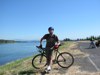
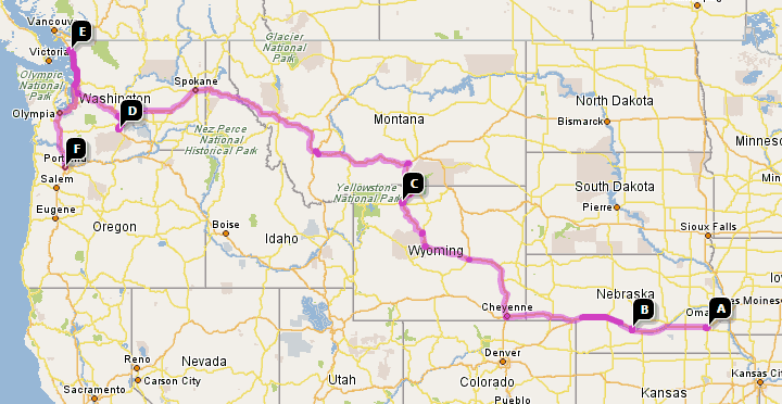
Emily and I rode a large section of the 40 mile loop yesterday. We rode from her place at John’s Landing to the Springwater Corridor and followed it out to Gresham, then north on 257th to Marine Drive, Marine Drive to I-205, the I-205 path back to the Springwater, then back to John’s Landing. 46.6 Miles. Here’s the replay with a few observations of my own (read: sarcasm)

Andy on the loop

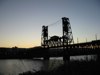
To start with, we had to cross the Sellwood Bridge. If it wasn’t my second time crossing it, and I didn’t have an enjoyment for trials riding, I’d hate it. And I get the feeling that most people do hate the Sellwood bridge, at least when trying to cross it. You do get a nice view from atop it though, and you can see our lovely city to the north and an active, tree lined river to the south. I’ve heard that the Springwater is supposed to connect with the river trail at some point, but we weren’t sure if it was done, so we followed Tacoma St. through Sellwood to where it intersects Johnson Creek Blvd and joined the Springwater Corridor trail.

The Springwater Corridor is probably one of, if not the best bike trails I’ve been on. The trail itself is perfectly flat – owing to it’s history as a railway grade. The section from Oaks Bottom into town has been recently paved and you sometimes have trouble remembering to enjoy it as you can really pick up a nice clip. East from Sellwood winds though neighborhoods and wooded areas following Johnson Creek much of the time, and crosses major roads with crosswalks and lights. The trail also passes a number of parks, such as Beggars Tick and Powell Butte, where we took a small side trip.
on top of Ol' Powell Butte

Both Emily and I recently got cyclocross bikes, and this was our first chance to try them on a trail. The climb up to the “summit” was easy and I was pleased by the performance by Jake. At the top of the Butte are the remains of a former orchard and a great view of the surroundings. We followed the orchard trail around the butte to get the full panorama. There wasn’t a cloud in the sky, which should have meant a great view, but a dirty brown smog blanketed the lowlands and the air was quite hazy. Still, the view of Portland, Vancouver, Camas, Gresham, Oregon City, and the four tops (Mt. Jefferson, Mt. Hood, Mt. Adams, and Mt. St. Helens…er… 3 tops anyway). Activity started to pick up by this time, and what looked like a group of school kids (on a Saturday?) an parents were at the top enjoying graham crackers and the view.

Back on the trail we started to see other riders and walkers out as we approached Gresham. We also saw a couple Nutria, some mallards, 3 pair of wood ducks, and a peeved domestic goose who was fed up with our gawking.

We got off the trail again at Gresham’s Main City Park to grab some lunch at the farmer’s market. We somehow ended up in the Teddy Bear Parade trying to follow a float that said it was from the farmer’s market, and eventually found our way back. Sadly, there wasn’t really anything to eat other than hot dogs so we stopped at Jazzy’s Bagel shop to refuel. I think farmer’s markets should have a giant public grill and some olive oil and salt so people can buy fresh veggies and grill them on site. That would have been a terrific lunch.

From Gresham, we followed the trail to Hogan Rd. then north to Division to 257th because the map suggested the trail was incomplete beyond that point. We followed 257th down to Marine Dr – and although there was a bike lane on the road, it was probably the least interesting and least inviting part of the ride. But once you get past the confusion of the Troutdale outlets and the Troutdale Airport, the path starts up again and winds between the Columbia River and parts of the slough. To our amazement, we had just been looking at this area from the top of Powell Butte.
Emily along I-205

Eventually , you end up on the levee or a path just below the levee on the river side. Mt. Hood is behind you (or in front, depending on your direction) and the occasional overhead jetliner. It’s fun to watch the barely floating giants pass overhead at a speed which seems inadequate to keep them in the air. You can expect some headwind along this stretch since it’s on the river.

From Marine Dr., we took the I-205 trail south to the Springwater. The trail gets a little confusing in some places where you cross in traffic, but it’s much nicer than you’d expect. It’s surprisingly quiet on the trail. I was surprised and pleased by the courtesy of drivers who stopped to let us cross the major arterial. I know there were crosswalks, but still – even as a pedestrian conscious driver, I often race to beat them.

By this time, we were both quite tired and quickly cruised back on the Springwater trail to Johns Landing. We were both pleased to know that we could – should it ever become necessary – ride the entire trail. In fact, once the 40 mile loop is complete, it would be a blast.

For the complete set of pictures – see here. For previous section postings, see here.

40 Mile Loop, Part 1

As a sort of penance for failing to turn in my field journal (and then loosing or recycling it during our move), Mike Houck has allowed me to make up the difference with a little make-up work. The deal we made was that I get to keep my grade if I ride and blog about the 40 mile loop (with pictures). He figured it would be fitting since I showed him two previous postings related to the class, and I can only guess the PR section of his brain thought this would be an appropriate replacement. I could have recreated the field notes in excellent detail in roughly an hour, but I figured this would a great motivation to actually ride the trail (in sections) this summer. Today I did the North Portland stretch out to Kelley Point.

Unfortunately, much of the 23 mile ride wasn’t actually on the loop, and large sections of the loop are still incomplete. Imagine my surprise, for example, when I reached a sign out by Kelley Point that said “40 mile loop – End.” Call me crazy, but I thought loops didn’t have “ends,” but rather looped around forever.

I rode out to the NoPo section of the trail by the Portland International Speedway on Interstate Ave. The trail starts in an industrial area along the Columbia Slough and pretty much stays in one for the entire stretch out to the point. There is a brief break near the Smith/Bybee Lakes Wildlife Refuge, but you’re still next to train tracks. I only saw one other biker on the trail at 10am on a Saturday, which was a bit of a surprise. The refuge was also deserted (of birds) though a few families were out walking.

Once I reached Kelley Point, I rode out to see it and was pleased to find another place where Barley might be able to get some swimming in. As I started back, I encountered the “end” of the trail and decided to follow Lombard or Marine Dr south and hopefully around to the St. Johns Bridge. Sadly, there were detours and I got lost as a result of losing my map. At one point I smelled what I thought were bad deli sandwiches, which I then figured out was because I was smelling pickles. Sure enough, a little bit later I passed a big food factory. By the time I made it back into a somewhat recognizable section of street names, I was beat, it was hot, and I was hungry.

I’ve got more to do now – including replacing the map. Maybe I can find it on the Internet somewhere.

Poor Grammar among cement works 90 years ago

Street name type
click for larger image

On one of my morning walks with Barley, I noticed a problem. The street names in the curbs on the corner of NE 23rd Ave and Emerson St didn’t all match. Three of the 4 corners list the named street as Surman St instead of Emerson. Was it a typo? Or was the street name changed from Surman during some brief period of anti-anglo sentiment? My final guess is that the concrete worker simply mis-heard the original street name Emerson as Surman and didn’t realize his mistake until the last corner. Either that, or someone else pointed it out. I’m sure the dope-slap was in use at the time (roughly 1911) and the person responsible got three of them.

Or more. One block up on the NE 23rd and Sumner St., another typo appeared. Someone had misspelled the street name as Somner on just this block. Oh, and the street was just East 23rd at the time of pouring.

One thing is clear from all this. Well, actually there are at least two of three things that are clear:

  1. Living in an old neighborhood is awesome
  2. whoever paved on NE 23rd nearly 90 years ago probably ended up in a different line of work
  3. I’m a total nerd

But I don’t want to choose

One of the most difficult things about buying a house in Portland is that you have to actually choose a neighborhood. There are so many cool little niches around the city that it is impossible to choose the one and only place that is perfect for you. I harbor some resent for having to choose a place. At least it’s still easy to get around to the others.

The other difficulty is leaving our current neighborhood. I joke about southwest being a cultural void, but I love it out here. I’m close to work, family, parks, Hillsdale, Multnomah Village, and downtown. I’m really going to miss driving into downtown on Barbur blvd. and seeing Mt. Hood and St. Helens above the city as it sits on the river and sprawls out to the east. Driving home is just as cool though because you look into your rear-view mirror and get not only the cars behind you but often a few skyscrapers and the low slope of a snowy mountain. It’s really gorgeous, and a quick and easy journey.

Still, we can’t really walk to anything worth walking to. A methodist church, the Castle Superstore, Blockbuster, and a liquor store. I’ll miss Barbur World Foods though; it’s going through a fascinating renovation. I’m also going to miss the birds, the neighbors (some of them), and Barley and my excellent walking routes.

Anyway, time to stop opining and stark opacking.