Yahoo Maps Beta

movement in yahoo maps
I stumbled upon Yahoo’s maps beta while reading fark today and wanted to see what made it unique. I love google maps, so Yahoo has some impressing to do if they want to woo map geeks.

My First impression is that the interface is kind of busy but not in a work stopping kind of way. The tool uses Flash which is kind of choppy on my 3.8GHz work machine. There’s a live zoom tool and panning which is one of the greatest features of goggle maps. It makes for improved discovery to be able to pan around and see the area around your point of interest and judge scale and location.

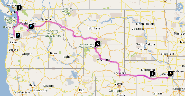
A big improvement is the multi-stop destinations. For a sample I did a map of my westward migration since birth (right) which yahoo attached some driving instructions for. This will be a lot of fun and quite useful because no matter how much you’d like to stop by some place on your trip from A to B, most web mapping services don’t allow it.

There’s also a Live traffic tool which I remember hearing about last year at the WebVisions conference. There’s also support for yahoo’s local directory which like google’s is of only limited usefulness.

It’s still in beta, but it looks pretty good.

More Google Earth as a harbinger of decay

The Register has a mostly humorous but somewhat serious look at how Google Earth is giving anyone access to view places that would have been unthinkable 50 years ago. I find the comments made by the Indian officials to be somewhat comforting. I love access to information – especially geographically significant information. It’s possible that tools like this could be used in terrorist attacks, but I think it’s unlikely that removing access to them will hinder them. And so much more can be done with that information. Still, you know people will continue to freak out the first time they see tools like Google Earth.

Google(‘s) Earth

I kept getting ready to post about Google’s 3rd incarnation of Keyhole – Google Earth, but I can’t get it installed on a workstation with a decent video card for some screen caps and video clips to make a fancy, media rich review. Plus, Google has taken the download offline because of what I imagine are bandwidth issues. I spent a fair amount of time trying to move preferences, caches, registry keys, etc. to another computer, but Google’s servers won’t recognize any newer installations. Damn, must be an IP thing.
Mt. St. Helens - Duh
Like Greg, I can’t help but drool over this great app. There’s even innuendo on the website about a mac version…

I’m still a little partial to Nasa’s World Wind, which I think has more elegant movement and navigation, but it’s also not available for the mac. World Wind is open – so anyone could conceivably build layers to use with it. With some of the options in Google Earth, it looks like community add-ons will be available soon.

It’s interesting to see two (three if Microsoft actually starts shipping products) versions of the Digital Earth developing. While I hope for the success of World Wind, I couldn’t pick a better company to work on the private version.

A few gems from Google Earth:

  • Mt. St. Helens with terrain turned on at a 45 degree view
  • 3D buildings in Portland or Seattle
  • Driving directions. Wow. It’s like taking the trip twice!
  • It uses Google results inside the maps!

A few things I’d like to see changed:

  • the camera rotation it counter-intuitive – you spin the map instead of your view
  • you can’t change zoom on the fly
  • It uses Google results inside the maps
  • Maximum disk cache of 512MB
  • not yet available for the mac

GIS Data no secret

Conneticut’s Supreme Court ruled that GIS data cannot be withheld from the public on the ground that it may expose potential trade secrets or public safety issues. I find this a relief since access to data means students, companies and agencies can do meaningful and current research. Besides, like Justice Vertefeuille said:

Justice Christine S. Vertefeuille, writing for the court, rejected the argument that the trade secret exemption could apply to the electronic GIS maps. All of the information contained in the maps is available piecemeal from other town departments, so there is nothing secret about them, she wrote.

Not to mention – our taxes generally pay for the collection of this data. We should have access to it. And while I would prefer free access to it, I have no problem with agencies charging for it, especially when they have a sliding cost scale.

3DSF

in what will ultimately be used to improve the realism of the late mac classic “Vette,” Google & Standford will start mapping San Francisco in 3D. The reasoning? Well, in the original game you could change the gravity so that when you jumped on a hill you’d sail through the air. A 3D map of SF would let you know exactly which building you’d be careening into the 6th story of.

Laugh if you will, but after playing that game I knew my way around San Francisco. Not that I was old enough to drive, or that you need to drive in SF.