Cat Food Thief

Ever since we moved to the new place, Tigger’s cat food occasionally disappears. The whole bowl miraculously empties. Tigger, being a cat, is a finicky eater at best. He’ll only eat the food at the top of the bowl, no matter the bowl size or depth. Eventually, the bowl has month+ old food on the bottom and fresh food on top. So we figured that the missing food wasn’t from Tigger.

The food sits next to the cat door, so our fear was that one of the neighborhood cats had found their way in. This made us nervous, given our experiences with cats and houses. Michelle and I were going to try and find a web cam to catch the culprit, but Michelle decided to try moving the food before going with such a drastic scheme.

When the food moved, the disappearing food problem got worse. How? Well, you see, when a food bowl is on the ground, it’s very easy to eat out of without disturbing the bowl. When the bowl is moved to, say, eye level for Barley, it becomes more difficult to eat because you have to approach from a different angle and such.

Well, the bowl was emptied twice, both times tipped messily towards the edge of the cabinet and both times spilling water and food on the floor. This last time happened while Michelle and I went out for food. It was clear that Barley was the cat food thief. Busted.

Now we’re just curious as to why he stopped behaving. He had always been so good about not eating Tigger’s food. But he’s been eating less of his lately, and Tigger recently switched from Senior to Sensitive Stomach formula, and maybe it tastes better. Still, it’s not good for the Roo so we’re going to have to place it even higher.

40 Mile Loop: Esplanade

Steele Bridge
The my last stretch of the 40 mile loop is quite familiar – I ride it whenever I’m industrious enough to get up early and ride to work. I generally cross the river at the Hawthorne Bridge and follow the East Side Esplanade to the Steele Bridge before continuing home. It’s a great stretch of trail and is alive at all times of the day with various types of activity. Walkers, runners, cyclists, dragon boaters, kayakers, people fishing and transients all use the path.

I like the East side of the path better for some reason, and generally take it. This time I took the east side because dusk made the west side too dark for pictures. Here are a few that I snapped from my ride home.

As a side – I think it would be great to change the “Vera Katz Eastside Park” to “Vera Katz Platz.” Less syllables and a more official name.

Quotes from the neighborhood

In the last couple weeks I’ve heard some great quotes. Some were directed at me, others simply overheard in public.

  • “Are you the type that wears alligator shoes?”
  • “Does it look like they they have bubblegum here? Do you see anyone chewing bubblegum? Do they have a bubblegum machine?”
  • “Don’t let him [barley] bite me, I just got up.”
  • to Beth “Can I have a hug?”

I suppose context is what makes them funny, but they might be funny without it. The first one was some lady asking me as I walked Barley at 6:30am last week. The second was at the new brewpub from a guy to his son who was tired of waiting. The third was also while walking Barley, though Barley was on a leash and wasn’t even posturing in a menacing way. The fourth was yelled by some gringo with a white bandana in the back of a packed RX-7.

3/4 of the 40 mile loop

Emily and I rode a large section of the 40 mile loop yesterday. We rode from her place at John’s Landing to the Springwater Corridor and followed it out to Gresham, then north on 257th to Marine Drive, Marine Drive to I-205, the I-205 path back to the Springwater, then back to John’s Landing. 46.6 Miles. Here’s the replay with a few observations of my own (read: sarcasm)

Andy on the loop

To start with, we had to cross the Sellwood Bridge. If it wasn’t my second time crossing it, and I didn’t have an enjoyment for trials riding, I’d hate it. And I get the feeling that most people do hate the Sellwood bridge, at least when trying to cross it. You do get a nice view from atop it though, and you can see our lovely city to the north and an active, tree lined river to the south. I’ve heard that the Springwater is supposed to connect with the river trail at some point, but we weren’t sure if it was done, so we followed Tacoma St. through Sellwood to where it intersects Johnson Creek Blvd and joined the Springwater Corridor trail.

The Springwater Corridor is probably one of, if not the best bike trails I’ve been on. The trail itself is perfectly flat – owing to it’s history as a railway grade. The section from Oaks Bottom into town has been recently paved and you sometimes have trouble remembering to enjoy it as you can really pick up a nice clip. East from Sellwood winds though neighborhoods and wooded areas following Johnson Creek much of the time, and crosses major roads with crosswalks and lights. The trail also passes a number of parks, such as Beggars Tick and Powell Butte, where we took a small side trip.
on top of Ol' Powell Butte

Both Emily and I recently got cyclocross bikes, and this was our first chance to try them on a trail. The climb up to the “summit” was easy and I was pleased by the performance by Jake. At the top of the Butte are the remains of a former orchard and a great view of the surroundings. We followed the orchard trail around the butte to get the full panorama. There wasn’t a cloud in the sky, which should have meant a great view, but a dirty brown smog blanketed the lowlands and the air was quite hazy. Still, the view of Portland, Vancouver, Camas, Gresham, Oregon City, and the four tops (Mt. Jefferson, Mt. Hood, Mt. Adams, and Mt. St. Helens…er… 3 tops anyway). Activity started to pick up by this time, and what looked like a group of school kids (on a Saturday?) an parents were at the top enjoying graham crackers and the view.

Back on the trail we started to see other riders and walkers out as we approached Gresham. We also saw a couple Nutria, some mallards, 3 pair of wood ducks, and a peeved domestic goose who was fed up with our gawking.

We got off the trail again at Gresham’s Main City Park to grab some lunch at the farmer’s market. We somehow ended up in the Teddy Bear Parade trying to follow a float that said it was from the farmer’s market, and eventually found our way back. Sadly, there wasn’t really anything to eat other than hot dogs so we stopped at Jazzy’s Bagel shop to refuel. I think farmer’s markets should have a giant public grill and some olive oil and salt so people can buy fresh veggies and grill them on site. That would have been a terrific lunch.

From Gresham, we followed the trail to Hogan Rd. then north to Division to 257th because the map suggested the trail was incomplete beyond that point. We followed 257th down to Marine Dr – and although there was a bike lane on the road, it was probably the least interesting and least inviting part of the ride. But once you get past the confusion of the Troutdale outlets and the Troutdale Airport, the path starts up again and winds between the Columbia River and parts of the slough. To our amazement, we had just been looking at this area from the top of Powell Butte.
Emily along I-205

Eventually , you end up on the levee or a path just below the levee on the river side. Mt. Hood is behind you (or in front, depending on your direction) and the occasional overhead jetliner. It’s fun to watch the barely floating giants pass overhead at a speed which seems inadequate to keep them in the air. You can expect some headwind along this stretch since it’s on the river.

From Marine Dr., we took the I-205 trail south to the Springwater. The trail gets a little confusing in some places where you cross in traffic, but it’s much nicer than you’d expect. It’s surprisingly quiet on the trail. I was surprised and pleased by the courtesy of drivers who stopped to let us cross the major arterial. I know there were crosswalks, but still – even as a pedestrian conscious driver, I often race to beat them.

By this time, we were both quite tired and quickly cruised back on the Springwater trail to Johns Landing. We were both pleased to know that we could – should it ever become necessary – ride the entire trail. In fact, once the 40 mile loop is complete, it would be a blast.

For the complete set of pictures – see here. For previous section postings, see here.

More Google Earth as a harbinger of decay

The Register has a mostly humorous but somewhat serious look at how Google Earth is giving anyone access to view places that would have been unthinkable 50 years ago. I find the comments made by the Indian officials to be somewhat comforting. I love access to information – especially geographically significant information. It’s possible that tools like this could be used in terrorist attacks, but I think it’s unlikely that removing access to them will hinder them. And so much more can be done with that information. Still, you know people will continue to freak out the first time they see tools like Google Earth.

Rafting the Tieton

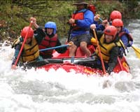
Saturday Michelle and I headed up north to Yakima to raft the Tieton river with family (including my surrogate brother Brent) and visit with other family.

This was Michelle’s first rafting trip, and currently the Tieton is swelling with water that is being released from Rimrock dam to make room for this winter’s water. I’d rafted the Tieton twice before with the Manfredis, but this was the first time I’ve ever been in a paddle raft.
freeds rafting
My mom won the tickets on the radio. I’m not sure how or when, but it was quite a score. Osprey, the guide company even had wet suits for us to use, which was an improvement over long underwear and rain pants.

The five of us shared one of the smaller play boats and our guide apparently though us the adventurous and responsive type because we got a great ride. The difference between this trip and previous was that I’m used to safely avoiding obstacles, and our guide (since it was his boat), playfully spun off a few rocks, and dipped us into a hole.

The pictures are great – and we got them from Osprey. Sadly, the one missing picture is the failed “Bow & Arrow” affair. You see – our guide instructed the paddlers on the left to hook their paddles onto a low-hanging cable as we passed under it. The idea was that they would hold on as long as possible and then let go – shooting the paddles back at the other rafts. But he didn’t tell us that. And, I missed the part about the people on the left doing it, so I stood up and hooked the cable too, and then didn’t know what to do so I held on as best I could and was pulled out of the boat, (Canoers aren’t supposed to ever let go of their paddle) pulling Brent into the water with me.

It was hilarious, and the water was fairly shallow and really quite warm, so we drifted a bit and go back into the raft to the cheers of the other boats in our flotilla. I suppose I should be more embarrassed, but it was fun, and the water was nice.

The ride lasted roughly two hours and was followed by a satisfying lunch. People were smiling knowingly at me. “There goes the guy who didn’t listen to his guide, then didn’t let go.” Yeah, well it was fun and I don’t regret it. I just hope Brent didn’t mind going for the ride with me.

Meg and Troy get hitched

Congratulations to Meghan and Troy on a wonderful wedding and best wishes to them in the coming years. We love you both and hope the honeymoon goes well. If you can travel together, there’s little you can’t do.

The wedding itself was marvelous. Meghan was glowing and Troy was calm and confident. If you don’t believe me, look at the pictures.

Bicycle Respirator

Traffic on Broadway yesterday largely consisted of large trucks and delivery vans. Most were diesel burning beasts that are exempt from DEQ emission standards. The fumes and exhaust were nasty and you could feel the particulate at times, and the pace going up Broadway ensured that you were always paired with a van, truck, or bus for most of the trip.

bike respirator, mon

The effects of the exhaust and exertion did give me an idea though. A bicycle respirator! No – not those cumbersome full-face things, or even the avian-flu-nurse-like mask – something that could mount on the handlebars and allow you to use it only when you needed it – only when you were in a thick cloud of nastiness.